Model Description
RIOSS is a set of open-source routines capable of identifying oil-like spills based on random forest classifiers trained and tested on SENTINEL-1 SAR imagery. Both European Space Agency’s (ESA) Sentinel-1 A and B satellite data were used to develop our dataset and apply the proposed methodologies. These satellites have a C-band synthetic aperture radar (SAR) operating in the wide range and TOPS mode. Preprocessing of images makes use of ESA SNAP’s Sentinel Toolboxes. An optimized feature space to serve as input to such classification models, in terms of variance and computational efficiency. It involved an extensive search from 42 image attribute definitions based on their correlations and classifier-based importance estimates. This number included statistical, shape, fractal geometry, texture, and gradient-based kinds of attributes, all of them related to the imaged phenomena's physical aspects. Mixed adaptive thresholding was performed to calculate some of the features studied, returning consistent dark spot segmentation results. This process helped us to develop optimal random forest models, resulting in up to 90% accuracy. In a continual process, we mean to get even more reliable results.
-
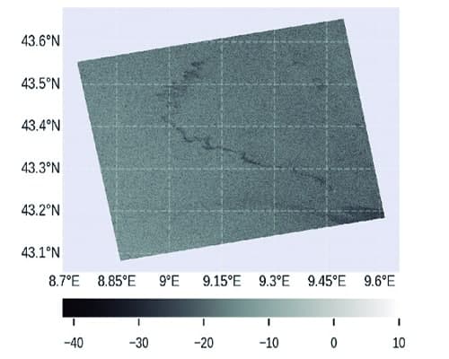
Image Input
-
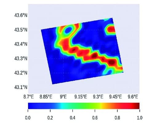
Oil Probability
-
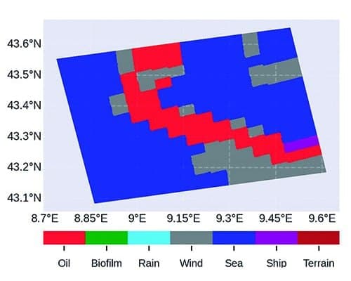
Output Classes
RIOSS is a set of open-source routines capable of identifying oil-like spills based on random forest classifiers trained and tested on SENTINEL-1 SAR imagery. Both European Space Agency’s (ESA) Sentinel-1 A and B satellite data were used to develop our dataset and apply the proposed methodologies. These satellites have a C-band synthetic aperture radar (SAR) operating in the wide range and TOPS mode. Preprocessing of images makes use of ESA SNAP’s Sentinel Toolboxes. An optimized feature space to serve as input to such classification models, in terms of variance and computational efficiency. It involved an extensive search from 42 image attribute definitions based on their correlations and classifier-based importance estimates. This number included statistical, shape, fractal geometry, texture, and gradient-based kinds of attributes, all of them related to the imaged phenomena's physical aspects. Mixed adaptive thresholding was performed to calculate some of the features studied, returning consistent dark spot segmentation results. This process helped us to develop optimal random forest models, resulting in up to 90% accuracy. In a continual process, we mean to get even more reliable results.